Riding into the Mountains and Waters of Xindian: A Climbing Memory Along the Xindian River on the Southern Side of Lion's Head Mountain
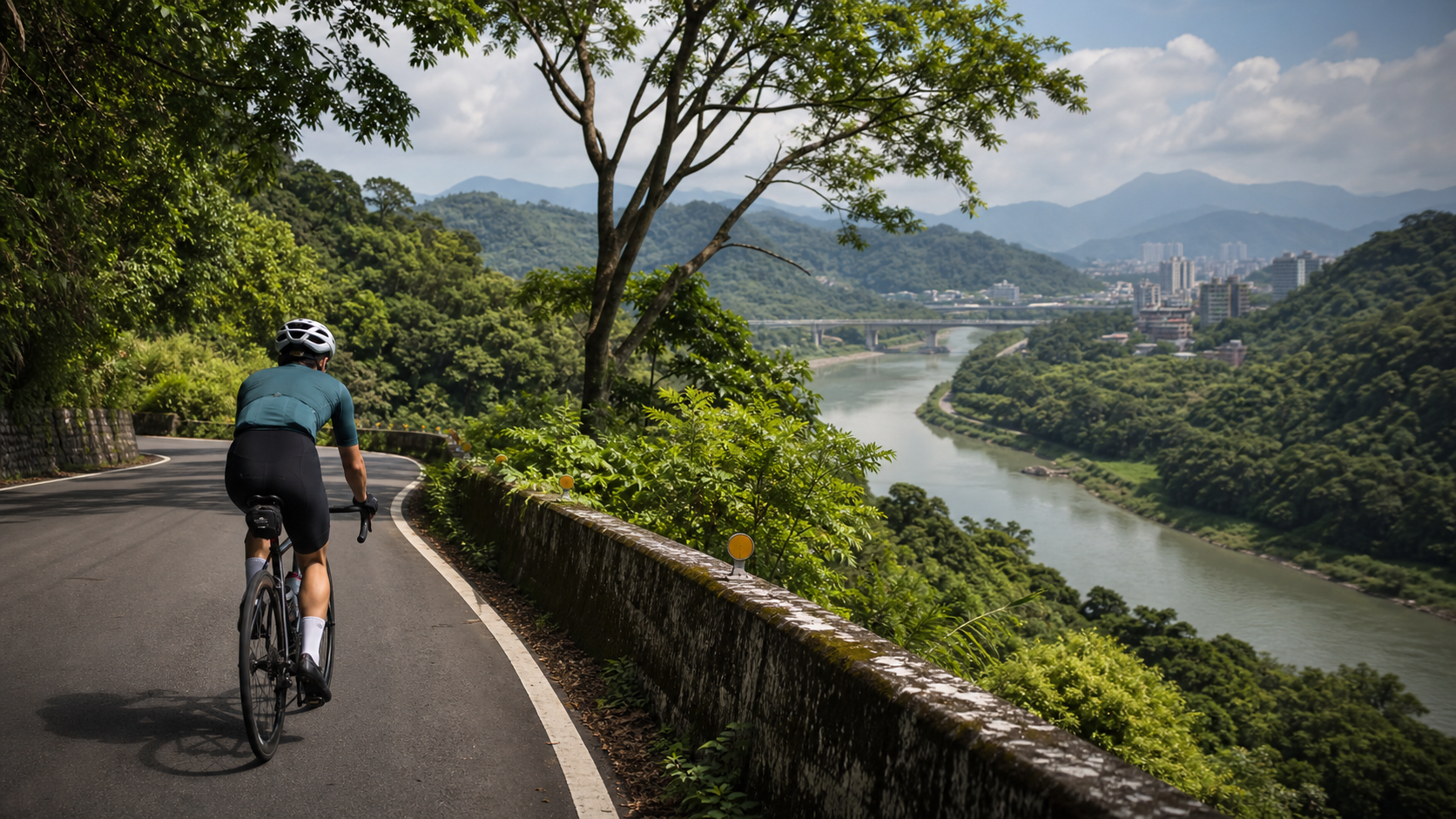
Riding into the Mountains and Waters of Xindian: A Climbing Memory Along the Xindian River on the Southern Side of Lion’s Head Mountain
As the wheels leave the bustle of downtown Xindian behind, the road slowly heads south along the banks of the Xindian River. The streetscape gradually shifts from dense rows of buildings to scattered houses and lush woodlands, and the air begins to carry a moist blend of river water and vegetation. This is Xindian’s distinctive sense of geographic layering—within just a few kilometers, the boundary between city and mountain forest is gently crossed. The climbing路段 on the southern side of Lion’s Head Mountain lies hidden precisely at this junction of mountains and water. At 7.64 kilometers in length with 499 meters of total elevation gain, it may not rank among the most formidable challenge climbs in Taiwan’s cycling circles, yet it carries a unique, shared local memory belonging to both Xindian residents and the cycling community.
The name “Xindian” itself bears the historical traces of pioneering settlement. In the Qing Dynasty, Han settlers crossed the Xindian River to cultivate the mountain areas, setting up a few crude shops along the way to serve passing woodcutters and farmers with rest and supplies—hence the name “Xindian” (literally “new shop”). This is one of the most straightforward naming logics in Taiwan’s early place names, plainly telling of the land’s former role as a transit and supply hub. Today’s Xindian has long since evolved from a frontier settlement into a vital hub of daily life in the southern Taipei metropolitan area. Yet just by riding slightly toward the mountains, the original terrain of hills embraced by water and dense forests remains clearly discernible, and the southern side of Lion’s Head Mountain preserves this landscape relatively intact.
This article aims to introduce this route in a different way—not through gradient percentages, not through power or heart rate numbers, but through what you see and feel while riding this road, and what this landscape means respectively to locals and visiting cyclists.
Lion’s Head Mountain, Hemei Mountain, and the Xindian River: A Hill Terrain Surrounded by Water
To understand the geographic context of the climbing route on the southern side of Lion’s Head Mountain, one must first zoom out and look at the overall layout of mountains and rivers in the Xindian area. The Xindian River winds down from the southern mountains, flows through downtown Xindian, and continues north to merge into the Tamsui River system. Along the banks of the Xindian River lie several hills of varying renown, with Hemei Mountain and Lion’s Head Mountain among them. Though these hills are not particularly high in elevation, their unique terrain undulations formed by proximity to the river, combined with dense native vegetation cover, have long made them popular destinations for local residents’ leisure hikes and cyclists’ climbing training.
Hemei Mountain sits close to the banks of the Xindian River with relatively gentle slopes, and at its foot lies the Bitan Scenic Area—that gracefully designed Bitan Suspension Bridge spanning the emerald river is almost the most vivid impression every Taipei resident holds of Xindian. Heading south from Bitan toward Wantan, riding along the riverside road, the hills on both sides gradually converge, and Lion’s Head Mountain sits within this terrain sandwiched between mountains and water. The name “Lion’s Head Mountain” is said to derive from the mountain’s silhouette resembling a lion’s head—this practice of naming places after the shape of mountains is quite common in Taiwan’s toponymic system, adding a touch of legendary color to the hill.
Wantan is another place name worth mentioning—the Xindian River forms a pronounced meander bend here, with the water curving into an arc-shaped pool, hence the name. The Wantan area retains a relatively rustic riverside settlement character, and in recent years, with the rise of cycling and hiking activities, it has become a modestly well-known leisure destination in the Xindian suburbs. The climbing route on the southern side of Lion’s Head Mountain, to some extent, serves as an important corridor connecting this entire Xindian River water system with the surrounding hill terrain. As cyclists climb, they are in fact following the landscape脉络 of this interwoven mountain-and-water terrain, ascending step by step.
This terrain of mountains beside water also gives rise to the unique microclimate and vegetation landscape of Lion’s Head Mountain’s southern side. The moisture brought by the river keeps the roadside foliage exceptionally verdant. Even in the height of summer, riding through tree-shaded sections still offers a coolness several degrees lower than in the urban area. This natural temperature-regulating effect is one of the reasons many local riders who know this route well are particularly fond of Lion’s Head Mountain’s southern side—it is not merely a training climb, but a healing route where one can feel surrounded by nature while riding.
First-Person Riding Narrative: The Afternoon I Decided to Ride the Whole Way
The first time I rode up the southern side of Lion’s Head Mountain was on an ordinary weekend afternoon. I had originally planned only to casually loop along the Xindian River, enjoying the riverside breeze, when at a certain intersection I noticed quite a few cyclists turning one by one onto a road heading toward the mountains. Driven by curiosity, I followed them in.
The initial section was still relatively gentle, with trees on both sides gradually growing denser. Sunlight filtered through gaps in the branches and leaves, casting dappled, shifting patches of light on the asphalt. At the time, I had no idea I had entered a climbing route fairly well known in cycling circles. I was simply following the road ahead and riding upward, until my thighs began to feel noticeably sore and heavy—only then did I realize this road demanded a longer, more solid climb than I had imagined.
After roughly two or three kilometers, I slowed down for the first time due to flagging energy, barely maintaining forward progress in my easiest gear with an extremely low cadence. Just at that somewhat disheveled moment, a local rider ahead of me—clearly experienced—slowed his pace, turned back, and called out: “Keep going! There’s a slightly flatter stretch ahead—push through and it’ll be easier!” This kind of encouragement between complete strangers is one of the warmest unspoken understandings in Taiwan’s cycling community—people who have never met, yet bound by a strange sense of camaraderie forged through sweating together on the same slope.
That encouragement indeed came true. The next short stretch saw the gradient noticeably ease, giving me a chance to catch my breath and recover. It was on that relatively flat section that I first had the leisure to lift my head and truly take in the surroundings—the glimmer of the Xindian River in the distance sparkling under the afternoon sun, the trees on the nearby slopes swaying gently in the breeze, and the occasional birdsong weaving between the sound of the chain turning and my breathing. In that moment, I suddenly understood why so many cyclists are willing to return to this route again and again—it offers not just physical conditioning, but an immersive sense of dialogue with nature.
After completing the full climb and reaching the open viewpoint at the summit, looking back at the road I had traveled, that complex emotion mixing fatigue and accomplishment is likely a shared experience familiar to all riders of climbing routes. From that day on, the southern side of Lion’s Head Mountain became one of my regular routes. With each ride, my body’s memory of the gradient grows sharper, yet the scenery always brings something a little different—the shimmering river light on sunny days, the swirling mist after rain, the golden sunset in the evening hours. The changing seasons and weather keep this route perpetually fresh.
Scenic Landmarks Along the Way: A Visual Feast from Bitan to Wantan
One of the most captivating aspects of riding the southern side of Lion’s Head Mountain is the route’s geographic connectivity with well-known landmarks in the area, making the entire ride not merely a physical challenge but more like a small journey through Xindian’s mountains, waters, and local culture.
Bitan, as one of Xindian’s most representative scenic areas, features that red Bitan Suspension Bridge spanning the emerald river, complemented by boating activities and riverside trails nearby—a perennial favorite weekend destination for Taipei residents. If you plan the southern Lion’s Head Mountain ride in conjunction with Bitan, you can pause around Bitan before setting off or after completing the challenge, taking in the lake-and-mountain scenery of this open expanse of water and savoring a leisurely atmosphere a world apart from the steep climb.
The riverside road heading toward Wantan, meanwhile, reveals a distinctly different quality of scenery—compared to the more tourist-oriented atmosphere around Bitan, the Wantan area retains more of a rustic riverside settlement character. The road winds along the Xindian River, with the murmuring water on one side and gradually rising slopes on the other. Though this stretch is gentle in gradient, it serves as an excellent visual and psychological warm-up before reaching the starting point of the southern Lion’s Head Mountain climb, allowing riders to adjust their pace and mindset through the river light and mountain scenery before formally taking on the steeper slopes.
The Hemei Mountain trail system and the area around Lion’s Head Mountain are weekend hiking destinations for many local residents. On the mountain paths, one occasionally sees hikers and cyclists passing each other, creating an interesting scene of shared space among outdoor sports communities. Though this mountain area is not particularly vast, its rich terrain undulations and diverse vegetation layers offer considerable ecological observation opportunities—the flowering cycles of plants through the changing seasons, and the occasional appearance of wild birds, are natural details worth slowing down to savor during a ride.
It is worth noting that in recent years, the flourishing popularity of hiking and cycling has attracted increasing numbers of visitors and sports enthusiasts from outside the area to explore this riverside landscape of Xindian. This growth in foot traffic has, on one hand, brought vitality to local tourism and commerce; on the other hand, it has prompted local residents and the long-time cycling community to engage in more diverse thinking and discussion about how to balance environmental protection and local quality of life while promoting sports tourism.
Local Culture and Cuisine: Rewards and Warmth After the Ride
After a long climb, what riders look forward to most is often not just the sense of accomplishment from completing the challenge, but also the food and rewards that follow—and the Xindian area happens to offer a remarkably rich and diverse selection of culinary options, more than enough to satisfy riders’ cravings after burning a substantial number of calories.
Around downtown Xindian, a number of traditional snacks and well-known local eateries have gathered, ranging from noodle dishes and street food stalls to cafés and light-meal shops. The choices are quite varied, catering to different riders’ taste preferences and refueling needs. As a scenic tourist area, the Bitan lakeside also hosts several shops offering light meals and drinks, making it suitable as a rest and refueling stop midway through or at the end of a ride. Since shop turnover and business hours change over time, riders planning their routes are advised to rely on on-site information at the time of their actual visit, or refer to the latest posts from local riding communities, in order to find shops that are truly suitable and currently open.
Xindian’s local culture is, to a certain extent, also reflected in the interaction between the area’s residents and the cycling community. As a key residential and commercial zone on the southern side of the Taipei metropolitan area, Xindian itself has a considerable number of local cycling enthusiasts. Combined with the popularity of the climbing routes around the southern side of Shitoushan and the Wandan area nearby, a distinctive local rider culture has gradually taken shape—seasoned riders familiar with the roads are happy to share training insights and route information, while newer riders build their familiarity with the landscape through repeated rides, fostering a community atmosphere of exchange that spans generations and experience levels.
This local warmth is also embodied in countless subtle everyday interactions—enthusiastic residents pointing the way at intersections, fellow riders encouraging one another mid-climb, and cyclists at rest stops willing to share supplies or tools. These seemingly trivial acts of kindness accumulate to form the deeper reason why the route on the southern side of Shitoushan keeps riders coming back again and again, unable to forget it. It is not merely a climbing route on a geographic coordinate; it is a riding ground that carries the warmth of local human connection.
What the Route Means to Riders: From Physical Challenge to Mental Stillness
For many riders who have long ridden the southern side of Shitoushan, the meaning of this route has long transcended the realm of pure physical training, gradually elevating into a space for mental stillness and reflection.
Modern urban life moves at a rapid pace—information overload and work-related stress pile up layer upon layer. Many people choose cycling as an outlet for stress relief, and the high-intensity, full-concentration nature unique to climbing routes happens to provide a rare experience of “forced focus”—on a steep slope, you have no spare mental energy to dwell on unresolved problems at work or the trivial worries of daily life. All of your attention is compelled to focus on breathing rhythm, cadence control, and the road immediately ahead. For many riders, this near-meditative state of focus is precisely the most precious moment for decompression and mental reset.
The natural surroundings unique to the southern side of Shitoushan—the streams, the forests, the occasional sounds of insects and birds—add a layer of healing to this focused experience. Compared to grinding away at gym equipment while staring at numbers, sweating through the climbs on the southern side of Shitoushan weaves the physical fatigue felt in the body together with the visual and auditory comfort offered by the natural environment, creating a unique sporting experience in which body and mind are nourished in unison.
For some local riders who have long been settled in Xindian, the southern side of Shitoushan carries an emotional connection akin to “memories of home.” From the awkward clumsiness of riding this route for the first time in youth, to the confident familiarity years later of handling every gradient transition with ease, this route has witnessed the trajectory of each rider’s physical and mental growth, and has also recorded the subtle changes in this landscape over the decades—which sections of road have been repaved, where the trees have grown denser, which corner has a new shop. Through repeated rides, these subtle changes are quietly woven into the deep emotional bond between local residents and this land.
Seasonal Scenery: The Southern Side of Shitoushan Through the Four Seasons
Because the Xindian area sits close to rivers and hilly terrain, the changing seasons present strikingly distinct visual layers along this route. Each season has its own unique scenery, well worth repeated visits by riders who wish to savor every detail.
Spring (March to May) is the time when vegetation on Xindian’s hillsides is at its most vibrant. Tender green buds sprout from the trees along the way, and wildflowers can occasionally be spotted dotting certain sections. Combined with the relatively pleasant temperatures of the season, this is one of the most comfortable times of year to take on the southern side of Shitoushan. Riding in the early morning, one can often sense the fresh fragrance of soil and vegetation mixed together after spring rains—a seasonal experience for the senses that is difficult to fully convey in words and can only be truly appreciated through firsthand experience.
In summer (June to September), the Xindian riverside displays lush, vigorous greenery. Dense tree canopies provide natural shade along the climbing sections, and with the moisture from the river helping to regulate temperatures, even on hot summer days, riding through tree-covered stretches still offers a relatively cool and pleasant sensation. However, the afternoon thundershowers common in summer require special attention; it is advisable to set off in the early morning to avoid the potentially unstable weather that may arrive in the afternoon.
In autumn (October to November), the skies over Xindian are usually exceptionally clear. The river water takes on an especially crystalline hue under the autumn sunlight, and with cooler temperatures and lower humidity, this is the best seasonal window of the entire year for extended outdoor exercise. Many veteran riders specifically recommend visiting the southern side of Shitoushan in autumn to enjoy the uniquely refreshing riding experience and expansive views that this season offers.
Winter (December to February) brings a completely different atmosphere—the northeast monsoon occasionally delivers cold, damp drizzle and localized fog to the Xindian hills. Under the veil of mist, the forests take on a hazy, poetic quality reminiscent of an ink-wash painting. Although the cold, wet weather increases the challenge of riding, for veteran riders who prefer challenging conditions and enjoy coexisting with the natural environment, the southern side of Shitoushan in winter offers a distinctly serene and understated flavor.
Suggested Side Trips: Incorporating the Southern Side of Shitoushan into a Full-Day Xindian Getaway
If you plan to make a dedicated trip to Xindian to take on the southern side of Shitoushan, consider making your itinerary more complete by incorporating the surrounding natural and cultural attractions, arranging it into a one-day light getaway that combines exercise and leisure.
The itinerary can start from the Bitan Scenic Area. Begin with a leisurely stroll or a cup of coffee around Bitan, soaking in the relaxed atmosphere of this expansive body of water. Then, follow the road along the Xindian riverside, passing through the riverside settlement scenery of the Wandan area, gradually connecting to the climbing section on the southern side of Shitoushan to complete this ride that combines scenery and challenge.
After completing the climbing challenge, it is recommended to pause briefly at the summit or a suitable viewpoint, looking down over the winding waterways of the Xindian River and the layered green of the surrounding mountains. Let the elevated heart rate from intense exercise interweave with the visual awe brought by the expansive view—this is often the most unforgettable moment of the entire ride.
On the return journey, consider stopping at a local eatery or café around downtown Xindian for a short rest, replenishing spent energy while allowing both body and mind to gradually return to calm at a leisurely pace. If time and energy permit, you might also consider arranging a short hike on the Hemei Mountain trail system, experiencing the charm of this landscape from a different perspective and through a different mode of movement.
For riders who prefer an in-depth exploration of local culture, doing some advance research on Xindian’s historical development and cultural stories can also be worthwhile, turning this ride into not just a physical workout but also an intellectual journey of understanding the cultural and natural context of this area on Taipei’s southern side. After all, what makes the southern side of Shitoushan so captivating has never been merely the data of its 7.64 kilometers and 499 meters of elevation gain, but rather the deep local memories woven from the interplay of people and nature, reclamation and daily life along the Xindian riverside over thousands of years.
Growing Old with This Landscape: The Generational Shift in the Cycling Community
On this route on the southern side of Lion’s Head Mountain, you’ll encounter all kinds of riders—from fully equipped, meticulously geared-up competitive cyclists, to elderly riders on commuter bikes leisurely taking in the scenery; from weekend groups riding together and chatting, to solo riders like me who enjoy the time spent in conversation with themselves. This diverse cycling ecosystem reflects the popularization of cycling in Taiwan over the past decade or so—evolving from a relatively niche athletic pursuit in the early days to gradually becoming one of the everyday leisure options for ordinary people.
Once, during a ride, I met an elderly gentleman who looked at least sixty, riding a road bike that appeared slightly aged yet well-maintained, climbing steadily at a relaxed pace. After striking up a conversation, I learned that he had been riding this route on the southern side of Lion’s Head Mountain for nearly twenty years—long before it was widely marked on sports community platforms like Strava—and had witnessed the entire transformation of the area from a relatively quiet mountain path to a popular riding route bustling with traffic on weekends. He said with a smile that in the old days, he might not encounter a single person all morning on this road, but now, early on weekend mornings, the slopes are already filled with cycling jerseys and bib shorts in every color imaginable. “It’s lively, sure, but sometimes I still miss the old days when it was quiet, just me and the mountains having a conversation.”
That conversation left a deep impression on me and got me thinking about how suburban routes like the southern side of Lion’s Head Mountain carry not just individual riders’ physical challenge records, but also serve as a microcosm of an entire generation’s cycling culture evolution. From the early days when riding was more solitary and route information could only be learned through word of mouth, to now, when anyone can easily look up precise distance, elevation gain, and gradient data through sports community apps, the barrier to entry for cycling has indeed been lowered, and participation has become more diverse. But that experience of being alone with nature, slowly building familiarity with the landscape, seems to have been somewhat diluted in the process.
It is precisely for this reason that I particularly cherish those moments when I choose to challenge the southern side of Lion’s Head Mountain on weekday early mornings, or during times when weather conditions are less than perfect—when tourists and crowds are relatively scarce, the mountain forest feels exceptionally quiet, leaving only the rhythm woven from the turning chain, tires against the pavement, and my own slightly heavy breathing. At such moments, you feel more keenly the route’s most primal and most moving essence—it has never needed a lively crowd to prove its worth. The mountain remains the same mountain, the stream still flows quietly, and the purest dialogue between rider and this land is always there, waiting for those willing to slow down and feel it with their hearts.
For Those Challenging It for the First Time: Some Sincere Advice
If this is your first time preparing to take on the southern side of Lion’s Head Mountain, beyond the data and tactics mentioned in the previous guide, I’d like to offer you a few suggestions from the perspective of someone who once struggled through the entire climb—suggestions that speak more to the mental and emotional side.
First, don’t place too much weight on your “completion time.” On your first attempt at this route, what you should focus on most is feeling the interaction between your body and this terrain—which section of the gradient feels particularly demanding, which turn suddenly opens up the view, which patch of shade feels especially cool and refreshing. These subtle physical sensations are far more worth savoring afterward than a cold number on a clock.
Second, allow yourself to stop along the way. Whether it’s because you’re running low on energy and need to catch your breath, or simply because you’re drawn to a particular view and want to take a longer look, the southern side of Lion’s Head Mountain has never been a racecourse that demands you finish in one go at all costs. A large part of this route’s beauty comes precisely from the unhurried ease with which it permits you to slow down and savor the scenery along the way.
Finally, approach the people you meet along the way with an open heart. Whether it’s fellow riders exchanging words of encouragement, or local residents kindly sharing road condition information, these seemingly small human interactions are often the very key that elevates a ride from a mere physical activity into a life memory worth revisiting again and again.
Every pedal stroke, every breath, is a process of dialogue with this landscape. The southern side of Lion’s Head Mountain is not just a climb written on Strava leaderboards—it is, in the hearts of countless riders, a unique Xindian memory woven from sweat, scenery, and the warmth of human connection.
Related Reading
- Complete Guide to Climbing the Southern Side of Lion’s Head Mountain in Xindian: 7.64 km, 499 m Elevation Gain, Section-by-Section Tactics from Beginner to Advanced
- The Sacred Mountain Steep Slopes of a Hakka Hill Town: Riding into Shitan, Encountering Xianshan
- The 100 km Miaoli Shitan Challenge: Leg-Strength Tests and Strategies for Rolling Terrain
- The Keelung Nuannuan to Pingxi Route: A Unique Riding Experience Through Northern Taiwan’s Mining Landscape
半日 小台灣 極限單車路線挑戰實錄
7 年前
虎豹潭!日本老師來台一日約騎 台灣車友熱情招待私房路線 / CT Yeh
19 天前
太平山單車員工旅遊 | 這樣玩CP值最高!| 公路車
5 年前
嘉義大埔、阿婆灣挑戰賽,美到以為在日本!ft. 環騎5 Cool 西拉雅188 / 公路車 / CT Yeh
7 個月前
單車 梅山36灣 坡度介紹 路段介紹 空拍 (相關遊記影片,請參考說明或我的頻道喔,歡迎訂閱)
6 年前
爬坡ITT實境)台中 魔王 松鼠坡 首航 6:12 大肚山 大三元 科福路
8 年前
大武山後門26%歡樂陡坡!JJSC南台灣單車行Day2 / 被颱風追著跑 / 公路車 / CT Yeh
2 年前
4K單車實境) 嘉義 梅山36灣 訓練台 爬坡 輕鬆騎
6 年前