The Majestic Ride on Suhua Highway: Cliffs, Sea Breeze, and the Unbelievable East Coast of Taiwan
Introduction
Some roads demand your full attention while riding, but after you finish, those images keep flashing back in your mind.
Suhua Highway is exactly that kind of road.
Provincial Highway 9 runs from Su’ao to Hualien, about 118 kilometers in total, hugging the cliffs along the Pacific coast the entire way. It is one of the most treacherous and spectacular roads on Taiwan’s east coast. For road cyclists, this route offers both technical challenges (long tunnels, steep slopes, gravel trucks) and visual feasts (cliffs, pebble beaches, azure waters)—a route every serious cyclist should experience at least once.
Before Departure: A Su’ao Morning
I chose to set off from Su’ao Train Station at six in the morning for a simple reason: gravel trucks on Suhua Highway are mostly concentrated between 9 a.m. and 3 p.m. Starting at dawn lets you pass through the most dangerous sections before the traffic peaks.
The morning at Su’ao Fishing Harbor carries the smell of the sea, and the streets are nearly empty. At a breakfast shop by the harbor, I had an egg pancake and two pan-fried buns, made sure my water bottles were full, and set off.
The section before Nan’ao is relatively flat, with a few small villages and convenience stores—the last convenient resupply area for the entire ride. I stopped in Nan’ao for a can of coffee, knowing full well: beyond this point, there are almost no shops for the next 70-plus kilometers.
Nan’ao to Horen: The Real Suhua
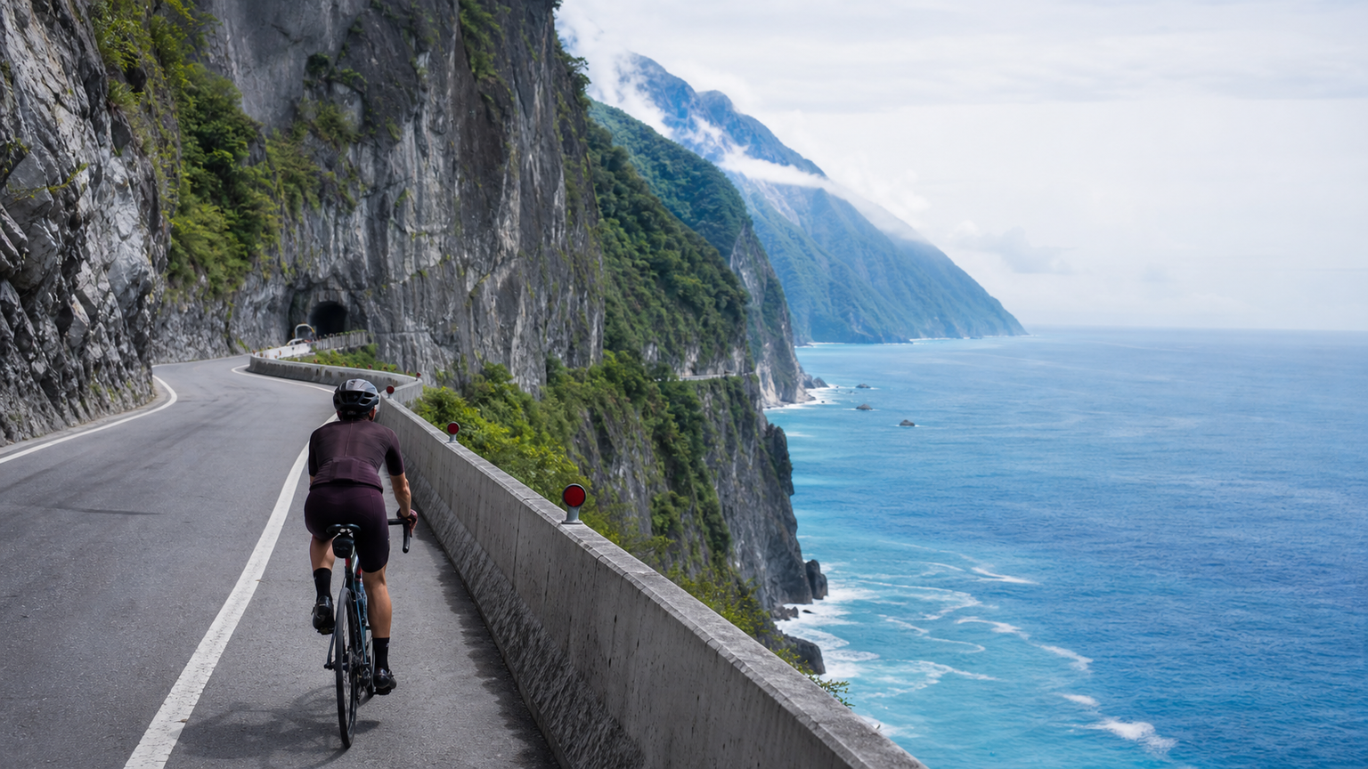
After Nan’ao, the road begins to hug the mountain wall tightly, and the Pacific on the right transforms from a distant view into a deep blue right at your fingertips. In some spots along the cliff section, the road is less than three meters wide. Every time a large gravel truck passed, the downward draft made me reflexively hug the shoulder.
| Section | Features | Main Challenges |
|---|---|---|
| Su’ao—Nan’ao | Gentle, has villages | Warm-up section, watch road conditions |
| Nan’ao—Horen | Cliffs, spectacular sea views | Frequent gravel trucks, narrow road |
| Horen—Qingshui Cliff | Most spectacular scenery of the entire route | Dark tunnels, rolling gradients |
| Qingshui—Chongde | Open views, gentle slopes | Relatively easy |
| Chongde—Hualien City | Flat road into the city | Complex traffic |
The Qingshui Cliff section is the visual pinnacle. The marble cliffs rise almost vertically from the sea to nearly 800 meters. White cliff faces, deep blue water, and the occasional mountain mist drifting down from the cliff tops—I stopped here for a full twenty minutes taking photos, completely forgetting I was on a bike.
Later I learned that many hikers spend a fortune flying around the world to see fjords, unaware that Taiwan has a cliff-side spectacle you can ride through slowly at 15 kilometers per hour.
The Darkness of the Tunnels: Suhua’s Most Overlooked Danger
Suhua Highway has multiple tunnels ranging from several hundred meters to over a kilometer long—the most caution-demanding part of the ride.
Lighting inside the tunnels is extremely poor, compounded by the noise and vibration of gravel trucks in the enclosed space. Every time I entered a tunnel, I turned both front and rear lights to maximum brightness, paused briefly at the entrance to let my eyes adjust to the dark, and confirmed no vehicles were closely following before entering.
Once, in a tunnel about 800 meters long, two gravel trucks suddenly appeared side by side behind me. The noise and lights closed in at once. I quickly moved to the far right, nearly touching the shoulder. After they passed, my heart rate spiked to 180 bpm, and it took a full five minutes to calm down.
Practical Advice
- Timing is critical: Set off before 6 a.m. and pass through the core dangerous section (Nan’ao to Horen) before 10 a.m. Avoid entering this section on weekday mornings between 8–11 a.m. (when gravel truck traffic is heaviest).
- Stock up on supplies in Nan’ao: The roughly 75 kilometers from Nan’ao to Hualien has almost no resupply points. Carry at least 1500–2000 calories of food and more than 1.5 liters of water.
- Tunnel safety preparation: A front light of at least 600 lumens, a rear light with radar function, and make sure all lights are fully on before entering a tunnel. Stay tight against the right shoulder.
- Always check the weather: Suhua Highway is frequently closed due to typhoons, heavy rain, or rockfall control measures. Check the Directorate General of Highways website (1968) before departure to confirm road conditions.
Conclusion
When I reached Hualien City, I sat down on the pebble beach at Qixingtan and gazed at the Pacific for a long time.
Behind me were the cliffs I had just ridden; ahead of me was the same sea. But seen from a different position, it felt completely different. Riding let me experience that distance with my body; now, sitting still, I finally had room to absorb its weight.
Suhua Highway is not an easy road, but what it gives you are images worth cherishing for a lifetime.
Related Reading
- Suhua Highway Ride Report: Cliff Scenery and Safe Cycling Tips
- Suhua Highway Full Ride Record: Taiwan’s Most Stunning Coastal Highway Experience
- Suhua Highway Cycling Challenge: The Complete Guide to Riding the Coastal Highway from Su’ao to Hualien
- East Coast Section: Suhua Highway Challenges and Safe Riding Guide
嘉義大埔、阿婆灣挑戰賽,美到以為在日本!ft. 環騎5 Cool 西拉雅188 / 公路車 / CT Yeh
7 個月前
微東進 太魯閣 蘇花 單車兩日遊 ! 颱風過後路況超刺激 行程大亂 | 最狂的鹹酥雞訂單 | CT Yeh | 4K 高畫質空拍絕景!
4 年前
單車環島 蘇花公路精彩片段
10 年前
台北闊瀨陡坡 騎旅 / 日本單車雜誌編輯車友臨時加入!/ 髮香才是最強的 / feat. 北迴歸線小隊 / 公路車 CT Yeh
6 個月前
大武山20%魔王陡坡【JJSC南台灣遊騎Day2】!屁股真的要裂開了...凡士林抹滿也沒用?神秘金教堂還有超便宜夜市
3 個月前
半日 小台灣 極限單車路線挑戰實錄
7 年前
公路車 | 塔塔加驚險員工旅遊 | 還好手腳快沒被抓交替!
5 年前
大武山後門26%歡樂陡坡!JJSC南台灣單車行Day2 / 被颱風追著跑 / 公路車 / CT Yeh
2 年前