Riding to the Peak of Taiwan: Sea of Clouds, the Couple Trees, and a Conversation with Yourself on the New Central Cross-Island Highway at Tataka
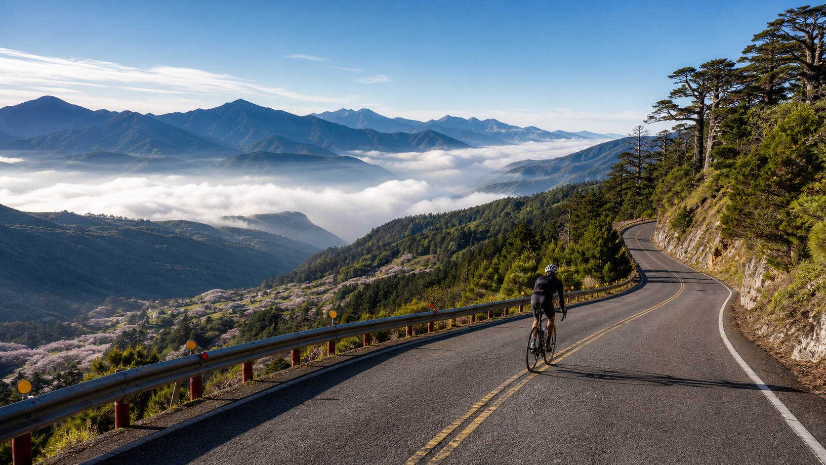
Some routes are meant for racing; others are meant for having a conversation with yourself. Tataka belongs to the latter.
The name “Tataka” comes from the Tsou language, meaning “a broad, flat grassland.” At an elevation of 2,610 meters, it is the highest point of the New Central Cross-Island Highway, where Provincial Highway 18 and Provincial Highway 21 meet among the mountains, resting quietly in the embrace of Yushan National Park. When you set off from Shuili, climbing gradually along the Chenyoulan River valley, passing through Xinyi, Heshe, Dongpu, and Shangdongpu, before finally reaching this alpine grassland in the thin air, you have ridden not just 70 kilometers of asphalt, but page after page of the geography and culture of Taiwan’s Central Mountain Range.
This article does not discuss pacing, gear ratios, or power output. It simply wants to take you, through a rider’s eyes and breath, to rediscover this classic route known as the “Peak of Taiwan.”
1. Setting Off from the River Valley: Plum Blossoms and Grapes by the Chenyoulan River
In the early morning in Shuili, the air still carries the moisture of the river valley. As you step onto the pedals and head upstream along the Chenyoulan River, the first thing to greet you is the pastoral scenery of Xinyi Township.
Xinyi Township is Taiwan’s famous home of plums. Every late winter and early spring, the mountainsides are covered in plum blossoms like snow, and a faint plum fragrance drifts through the air. When the harvest season arrives, plums, grapes, and high-mountain tea take turns taking center stage, painting a four-season picture of mountain agriculture. Riding along this relatively gentle valley road, you will unconsciously slow down—not because you are tired, but because you do not want to rush past it.
The beauty of the valley section lies in its “unhurriedness.” The river appears and disappears on your right or left, the ridgelines of distant mountains stack layer upon layer, and occasionally farmers are busy under grape trellises. This is the section of the entire route that feels most like a “journey” rather than a “challenge.”
Every village here has its own rhythm of life. You will pass through small settlements and see the daily lives of the locals. If time allows, strike up a conversation with the shopkeepers while resupplying, and listen to them talk about the mountain weather and this year’s harvest. These conversations will often stay with you longer than any landscape photo.
2. Heshe and Dongpu: A Transition Through the Hot Spring Town
As the elevation gradually rises, the route arrives at the Heshe and Dongpu area. This is an important transitional zone along the New Central Cross-Island Highway and a waypoint in many riders’ minds.
Dongpu is one of Taiwan’s well-known hot spring settlements. In the valley embraced by mountains, the steam of hot springs mingles with the crispness of the forest. Although riders usually “pass through” rather than “soak,” merely imagining a hot spring bath to soothe your legs after reaching the summit is enough to become a small motivation to push through the hard climbs ahead.
On this section, the road begins to show its temper. You can feel the temperature of your legs rising, and your breathing rhythm begins to require deliberate management. But the scenery rewards you just as generously—the mountains grow more majestic, the clouds hang lower, and you are gradually climbing from the “human world” toward the “heavens.”
3. Entering the Height of the Clouds: From Shangdongpu to the Couple Trees
Past Shangdongpu, the route officially enters its most soulful section. The elevation breaks through 2,000 meters, the air becomes thinner, the temperature drops noticeably, and the scenery upgrades from “magnificent” to “sacred.”
The most famous landmark here is the Couple Trees.
The Couple Trees are two giant dead trees standing beside the New Central Cross-Island Highway. They were once lush Taiwan red cypresses, reduced to standing deadwood after a forest fire, yet they continue to watch over the forest in another form. The two dead trees stand side by side, enduring wind, frost, rain, snow, clouds, and fog, unyielding for decades. Many riders stop here, not just for photos, but to draw some inexpressible strength from that weathered silence.
When you are at over 2,000 meters, legs heavy as lead, breath short, and you look up to see those two dead trees still standing tall after fire and time, you suddenly understand: persistence is not about not being tired, but about continuing even when you are.
From the Couple Trees upward, a sea of clouds often churns beneath your feet. In the early morning or at dusk, if the weather cooperates, you will see a vast sea of clouds spread out among the peaks, with the main peak of Yushan rising like an island above the clouds. At that moment, all fatigue is temporarily swept away by the sight, and you will be grateful that you reached this height in the slowest, most honest way—one pedal stroke at a time—rather than roaring past in a car.
4. Tataka Saddle: The Finish Line on the Broad Grassland
Finally, you arrive at Tataka Saddle. At 2,610 meters, it is the highest point of the New Central Cross-Island Highway and the gateway to the Yushan trailhead.
“A broad, flat grassland”—only when you stand here do you understand how fitting this name given by the Tsou ancestors truly is. Compared to the steep, tense mountain terrain along the way, Tataka Saddle opens up into a relatively gentle and expansive alpine grassland. The Tataka Visitor Center, the Big Iron Hemlock Trail, and the Yushan trailhead all gather here. This is the starting point for countless hikers embarking on their Yushan journey, and the finish line for countless cyclists on their two-wheeled expedition.
Standing on this grassland, you can gaze out at the Yushan range. The air is cold and crisp, and the sunlight is exceptionally clear in the thin atmosphere. You have completed a journey from the river valley to the mountaintop, with a vertical climb of over 2,500 meters. At this moment, no results sheet or ranking is needed—between you and this mountain, a unique understanding has already been forged.
5. Landmarks Along the Way and Suggested Side Trips
The New Central Cross-Island Highway at Tataka is far more than just a climbing road. It strings together an entire landscape of nature and culture. Below are the notable points worth paying attention to along the route:
| Waypoint | Feature | Significance for Riders |
|---|---|---|
| Xinyi Township River Valley | Plum, grape, and high-mountain tea region | Warm-up section, enjoy pastoral scenery |
| Chenyoulan River | The river valley running through the entire route | The sound of water and scenery accompanying you throughout |
| Heshe / Dongpu | Hot spring settlement, resupply waypoint | Important rest and resupply point |
| Shangdongpu | Gateway to high elevation | Scenery shifts from magnificent to sacred |
| Couple Trees | Dead tree landscape landmark | Spiritual anchor, photo and rest stop |
| Yushan Trailhead | Starting point for climbing Yushan | Milestone near the finish |
| Tataka Saddle | Highest point of the New Central Cross-Island Highway, visitor center | Journey’s end, panoramic view of Yushan |
| Big Iron Hemlock Trail | High-mountain primeval forest trail | Side trip for a stroll, relax the legs |
Suggested side trips:
- A walk around the trailhead area: After reaching Tataka, do not rush to descend. Walk a short section of the Big Iron Hemlock Trail to let your tense legs relax and to truly “be” in this alpine grassland, rather than just “passing through.”
- The hot spring thought for the way back: If your schedule allows, stop briefly in the Dongpu area after descending, and let the day’s fatigue slowly dissolve in the warmth of the hot springs.
- Agricultural souvenirs: Plum products and seasonal fruits from Xinyi Township make for warm and meaningful mementos of this journey.
6. Seasonal Scenery
The beauty of this route changes its attire with the seasons.
- Spring: Plum snow and fresh green. In late winter and early spring, plum blossoms bloom across Xinyi Township, and the valley section feels like a snow country; at higher elevations, trees begin to sprout new leaves, filling the entire route with vitality.
- Summer: Sea of clouds and greenery. In summer, afternoon clouds and mist churn in the mountains, making the sea of clouds more likely, but be mindful of sudden weather changes in the afternoon. Riders who set off in the early morning can often capture the most magnificent sea of clouds around the Couple Trees.
- Autumn: Clear skies and crisp air. Autumn is the season with the most stable weather and best visibility on this route. On cloudless days, the Yushan range appears so clear it seems within reach—the golden time for photography and panoramic views.
- Winter: Cold and biting. In winter, the high elevations are cold and biting, and cold snaps can even bring snow and ice. The risk of going up increases at this time, but the solitary beauty of utter stillness is something only the best-prepared can appreciate.
In every season, Tataka speaks to you in different words. Some come for the plum snow, some for the sea of clouds, some for the clarity of autumn. And no matter the season, when you have measured the distance from river valley to mountaintop on two wheels, this mountain will leave the same message in your heart: it was worth it.
7. The Meaning of This Route: An Upward Practice
Why are so many riders willing to spend the better part of a day, enduring thin air, leaden legs, and weather that shifts from sun to fog, just to reach Tataka?
Because this route is, at its core, a practice.
It is not like a short, steep climb that gives you a cathartic burst within minutes. It demands long patience, a steady rhythm, and the will to turn the pedals one more time on the most difficult high-altitude sections. In this process, you are forced into solitude with yourself—no phone distractions, no work noise, only breath, heartbeat, and the road endlessly rising before you.
When the ache in your legs reaches a certain threshold, your mind begins to quiet. The worries, anxieties, and entanglements that usually linger are temporarily cleared away by oxygen deprivation and focus. You will find yourself thinking less and feeling more—the shape of the mountains, the flow of the clouds, the temperature of the wind, the angle of the light. This is a state close to meditation, and it is the most precious gift of a long climb.
And when you finally reach Tataka Saddle, standing on that “broad grassland” of the Tsou ancestors, gazing at Yushan, what you gain is far more than the completion of a ride record. What you gain is a clearer, calmer, and stronger version of yourself.
8. The Story of the New Central Cross-Island Highway: A Road Through the Central Mountain Range
To truly understand Tataka, you must first understand the story of the New Central Cross-Island Highway beneath your wheels.
The New Central Cross-Island Highway is a road system connecting Taiwan’s western plains with the heart of the Central Mountain Range. It links Chiayi, Nantou, and the Yushan area, making the high mountains, once reachable only after long treks, accessible by wheel. Provincial Highway 18 extends from Chiayi toward Alishan and Yushan, while Provincial Highway 21 climbs from Shuili toward Yushan. The two roads meet at Tataka, forming the backbone of this classic “Peak of Taiwan” route.
For riders, the significance of this highway goes far beyond being “a road you can ride.” It is a living textbook that vertically traverses Taiwan’s vegetation zones—you climb from low-elevation broadleaf forests and farmland, through mixed coniferous and broadleaf forests, and finally reach high-elevation coniferous forests and alpine grasslands. In just 70 kilometers, your wheels measure a complete ecological microcosm of Taiwan, from subtropical to cold temperate.
When you ride from the grape trellises at the foot of the mountain to the mist-shrouded high-mountain hemlock forests in a single day, you are, in the slowest and most grounded way, flipping through a natural geography textbook of Taiwan.
Along the way, you pass through the boundaries of Yushan National Park. This national park, centered on Taiwan’s highest peak, Yushan, protects a precious high-mountain ecosystem. As riders, we are guests of this land and should carry respect—leave no trash, make no noise, do not disturb wildlife, so that those who come after can see the same pristine mountains.
9. The Land of the Tsou: The Story Behind the Name Tataka
The name “Tataka” is itself a story.
It comes from the Tsou language, meaning “a broad, flat grassland.” The Tsou are one of Taiwan’s indigenous peoples who have long inhabited the Alishan and Yushan area. Before Han settlers and modern roads arrived, this alpine grassland was already a place where Tsou ancestors lived, hunted, and migrated. They named this open saddle grassland with the most fitting words—when you stand on Tataka yourself, gazing at that relatively gentle and open alpine landscape, you will sincerely admire the precision of the name.
Riding this route means traveling over land that Tsou ancestors walked for generations. This historical depth makes Tataka more than just a geographic coordinate; it is a place carrying the cultural memory of indigenous peoples. When we approach this land by bicycle, a little more understanding and respect for indigenous culture adds another layer of depth to the journey.
In the Xinyi Township area, beyond the Han farming settlements, there are also traces of life from indigenous peoples such as the Bunun. Behind the plum, grape, and high-mountain tea industries lies a tapestry of life woven together by different ethnic groups in these mountains. These are the cultural landscapes worth savoring beyond the ride itself.
10. The People and Scenery You Meet Along the Way
The most enchanting part of a long ride is often the unplanned encounters.
In the valley section, you might meet early-rising farmers busy under grape trellises or in tea gardens. A simple greeting, a nod and a smile, instantly gives the cold asphalt a warmth of human connection. At a small resupply shop, the owner might add an extra word of advice: “It’s cold up there, take care.” Such an ordinary reminder becomes a warm current when you are at your most exhausted later on.
In the mountains, you might meet fellow riders taking on the same challenge. Camaraderie among cyclists at high altitude is particularly pure—a thumbs-up, a shout of “keep going,” even between strangers, can provide immense encouragement. On a high-altitude hard climb with thin oxygen and leaden legs, this mutual support is sometimes more effective than any energy gel.
You will also meet hikers heading to Yushan. Tataka Saddle is the location of the Yushan trailhead, always gathering hikers with big backpacks, about to begin or just finishing their Yushan expedition. Cyclists and hikers approach the same great mountain in different ways, and at this meeting point, there is a mutual understanding in each other’s eyes.
These encounters will not appear in your ride log, but they will stay deep in your memory. Years later, you may forget how many hours the ride took, but you will remember that stranger on the mountain who gave you a thumbs-up, and that phrase, “It’s cold up there, take care.”
11. Riding Solo or Riding Together?
This route suits both solo riding and group riding, each with its own flavor.
Riding solo allows you to fully immerse yourself in your own rhythm and thoughts. No one dictates your pace, no one interrupts your contemplation. During the long climb, you will engage in the most profound conversation with yourself. This solitary experience is Tataka’s gift to the lone rider. But the prerequisite for riding solo is “thorough preparation”—because rescue is difficult in the mountains, you must have sufficient confidence in your fitness, equipment, and ability to handle unexpected situations, and you must let family or friends know your itinerary.
Riding together adds a layer of safety and companionship. On the hardest sections, having someone beside you gritting their teeth too brings a sense of “I’m not the only one suffering” that greatly boosts your will to finish. Looking out for each other during resupply and supporting one another in unexpected situations make group riding more reassuring. Just be mindful that everyone’s fitness differs in a group, so agree in advance on the principle of “each rides their own pace, regroup at the finish,” and do not disrupt each other’s rhythm for the sake of accommodation.
Whether solo or in a group, Tataka will respond to you in its own way. What matters is choosing the way that best fits your state of mind at this moment, and properly, completely, riding this road to the end.
12. The Best Time to Depart: Setting Off with the Morning Light
If you ask me when the best time to start this route is, my answer is: the early morning before dawn.
The high-mountain morning has an indescribable magic. When you set off from Shuili in the faint light of dawn, the valley is still wrapped in a thin layer of morning mist, and the air is cool and sweet. The moment the first rays of sunlight cross the ridgeline, the entire valley is bathed in a warm golden glow. Riding through it, you feel as if you are riding into a landscape painting being painted stroke by stroke by the light.
Setting off in the early morning also has very practical benefits. You can complete the most difficult high-altitude sections before the afternoon fog and weather changes arrive. While those who slept in are struggling through afternoon mist and drizzle, you may already be standing on the sun-drenched Tataka Saddle, enjoying the joy of reaching the summit.
In the high mountains, “early” is not just a virtue of diligence; it is a strategy of safety. The morning light belongs to early risers, and good weather, too, often only waits for riders willing to get up early.
As the elevation rises and time passes, you will see the light shifting angles through the forest. Morning sunlight filters through the conifers, casting dappled spots on the road; near noon, the high-altitude sunlight becomes exceptionally clear and intense. This entire journey in the company of light is itself a reward reserved for those who set off in the early morning.
13. When You Want to Give Up
I must be honest with you: on this route, you will almost certainly experience a moment of “wanting to give up.”
That moment usually appears on the high-altitude hard climb in the fourth section. Your legs feel like lead, every pedal stroke is unbearably heavy; your breath is short, and no matter how much thin air you gasp, it never feels like enough; the gradient seems endless, one switchback after another. At that moment, your brain begins to negotiate with you: “Should I get off and rest?” “Riding this far is already pretty good, right?” “I can come back and finish it another time…”
These voices are all normal. Every rider who has stood on Tataka has wrestled with them.
What I want to share is this: when these voices appear, do not try to “eliminate” them with willpower—that will only exhaust you further. What you can do is shift your attention from “how much farther” to “this one pedal stroke right now.” Just focus, steadily, on turning one more stroke, and then another. Do not think about the finish line; just keep turning.
You will be surprised to find that when you are no longer crushed by the despair of “so far to go,” but instead focus on each pedal stroke before you, the road truly does get left behind, bit by bit.
Those who complete this route are never those who do not get tired, but those who, tired and wanting to give up, still choose to turn the pedals one more time. So-called willpower is not the absence of pain, but moving forward despite the pain.
And when you finally ride past the hardest section and see Tataka Saddle ahead, you will be sincerely grateful—grateful that at the moment you most wanted to give up, you did not. This sense of “I did it” will far surpass the satisfaction of any easy ride.
Conclusion: Meeting Another You at the Peak of Taiwan
The Tataka New Central Cross-Island Highway is a route that will make you rediscover Taiwan, and rediscover yourself.
It has the plum fragrance and warmth of Xinyi Township, the hot spring steam of Dongpu, the weathered watch of the Couple Trees, the vast magnificence of the Yushan sea of clouds, and that high-mountain saddle named “broad grassland,” quietly waiting for every traveler who measures it on two wheels.
If you are hesitating about whether to take on this route, what I want to say is: do not treat it merely as a goal of elevation gain. Treat it as a journey, a conversation, a practice. Prepare your equipment, and prepare your heart. Then, on a clear morning, set off from Shuili, toward that grassland above the clouds, one pedal stroke at a time, riding toward the Peak of Taiwan.
There, you will meet the sea of clouds, meet Yushan, and meet the quieter, more complete version of yourself.
Related Reading
- The Complete Guide to Tataka’s 20km Long Climb: Fully Coping with the High Altitude of the New Central Cross-Island Highway
- The Complete Tataka New Central Cross-Island Highway Climb Guide: Data Analysis of the 70km, 2,517m Climb to the Peak of Taiwan
- Tataka Climbing Guide: The High-Altitude Challenge at the Foot of Yushan
- Selected Nantou Mountain Routes: Five Stunning Mountain Roads Beyond Hehuanshan
阿里山塔塔加 兩倍特濃版!全新隧道開通! 進喔!公路車 | CT Yeh
3 年前
公路車 | 塔塔加驚險員工旅遊 | 還好手腳快沒被抓交替!
5 年前
爬坡ITT實境)台中 魔王 松鼠坡 首航 6:12 大肚山 大三元 科福路
8 年前
嘉義大埔、阿婆灣挑戰賽,美到以為在日本!ft. 環騎5 Cool 西拉雅188 / 公路車 / CT Yeh
7 個月前
藤枝二集團 單車行 Day1 | 南部小武嶺 | 爬坡爬到罵罵叫 | JJSC | 公路車 | CT Yeh
3 年前
台灣登山王之路 KOM 全程參賽4K臨空錄影 PART1 穿越峽谷地形! #東進武嶺 太魯閣 / 燕子口 / 天祥 / 西寶 PART1 (公路車 / CT Yeh)
3 年前
一定要騎一次!阿里山最深處:里佳部落!單車旅行 | 2800m爬升 | 深度部落體驗:嗨翻晚會、螢火蟲、銀河 | feat. JJSC & 廢物伙伴 | 公路車 CT Yeh
10 個月前
雙十節的溫腥感人約騎,升旗到升天一次滿足 | 公路車 | 鳳山寺 | 米粉坡
6 年前